#StandWithUkraine - Stop the Russian invasion
Join us and donate. Since 2022 we have contributed over $5,000 in book royalties to Save Life in Ukraine & Ukraine Humanitarian Appeal & The HALO Trust, and we will continue to give!
Georeference with Map Warper
Map Warper, an open-source tool created and hosted by Tim Waters, allows users to upload and georeference (also called georectify) a scanned map image. This means to precisely align the static map image on top of a present-day interactive map. As a result of this process, older map images often appear “warped” when updated for the digital age. After your map image is georeferenced and hosted on this site, a special link allows you to place this raster data as an overlay on an interactive map, such as Leaflet Storymaps with Google Sheets as described in Chapter 12. Anyone can create a free account to upload and georeference a map on the developer’s public Map Warper site. See also how the tool is used by organizations such as the New York Public Library’s digital maps collection.
Warning: While Map Warper is a wonderful open-source platform, service may be unstable. A July 2020 update states: “Ran out of disk space. Maps older than 2 years will need re-warping to work. Downtime will happen again.” We recommend that users be mindful of the platform’s limitations, but also consider donating funds to the developer to continue this open-source project.
Follow this abbreviated tutorial to create a georeferenced overlay map, based on a more detailed version by digital librarians Erica Hayes and Mia Partlow.42
Create a free account on Map Warper.
Upload a high-quality image or scan of a map that has not yet been georeferenced, such as an image of a paper historical map, and enter metadata for others to find it. Follow guidelines about fair-use copyright or works in the public domain.
After you upload the image, click on the Rectify tab in the Map Warper interface, and practice moving around the map.
Click to add a control point in the historic map window, then click to add a matching control point in the modern map window to align the two images, as shown in Figure 13.29. Good control points are stable locations or landmarks that have not changed during the time period between the two maps. For example, major cities, railroad tracks, or road intersections might be a good way to align maps from the early 1900s to today, depending on the map scale and historical context.
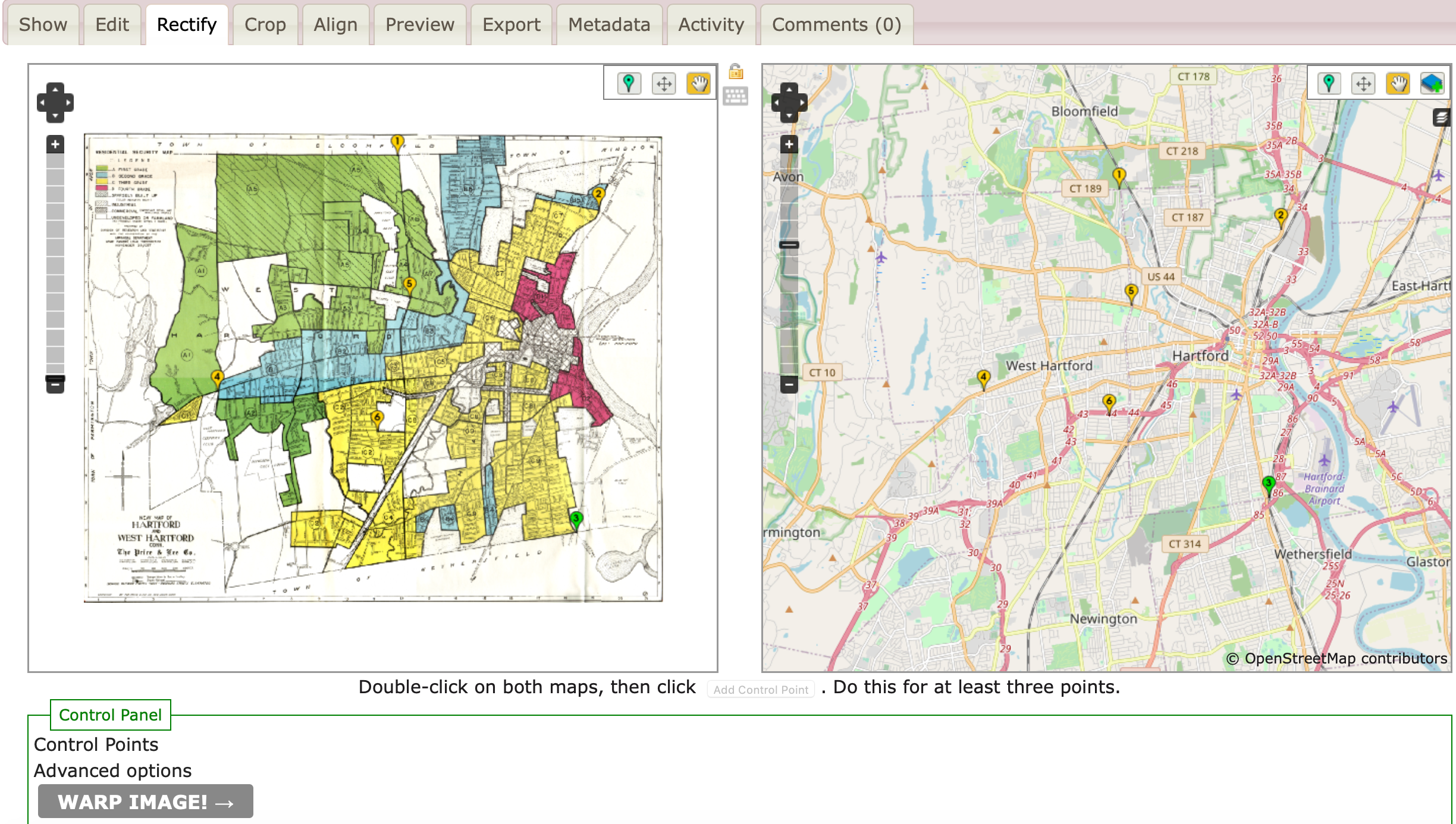
Figure 13.29: Add control points to align stable locations or landmarks between the historical map (on the right) and the modern map (on the left).
Add at least 4 or 5 control points to match the two maps and spread them out. When you are satisfied, click the Warp Image button at the bottom of the page. Map Warper transforms the static map image into a set of georeferenced map tiles, which now appear as a layer on top of the modern map.
Click the Export tab, and under Map Services, copy the Tiles URL that appears in Google/OpenStreetMap format, similar to this:
https://mapwarper.net/maps/tile/14781/{z}/{x}/{y}.png
- You can copy and paste this special Tiles URL into the Leaflet Storymaps with Google Sheets template as described in Chapter 12, or other web map tools or code templates that display overlay maps in this format. But it will not work if you paste it into a regular web browser.
You can search for historical maps that have already been georeferenced and transformed into tiles, or contribute to crowdsourcing efforts to align maps, on platforms such as Map warper and the New York Public Library Map Warper.
Erica Hayes and Mia Partlow, “Tutorial: Georeferencing and Displaying Historical Maps Using Map Warper and StoryMapJS” (Open Science Framework; OSF, November 20, 2020), https://doi.org/10.17605/OSF.IO/7QD56.↩︎